Navvego Precision
Software-based positioning reliability layer
- Works with existing receivers
- Not locked to a single correction provider
- Scales across regions without retooling
Keeps fleets accurate across regions without retooling.
Navvego adds a resilience layer to existing GNSS (GPS, Galileo, and other satellite) systems, delivering centimeter-level positioning, interference detection, and signal authentication without hardware replacement.
Deploy in days. Works with existing receivers.


Built by Aerospace and GNSS engineers with 15+ years shipping safety-critical navigation systems.
They delay deliveries, ground drone fleets, interrupt harvesting operations, and create measurable financial risk.
In positioning-critical environments, even short disruptions cascade into operational, financial, and compliance risk.
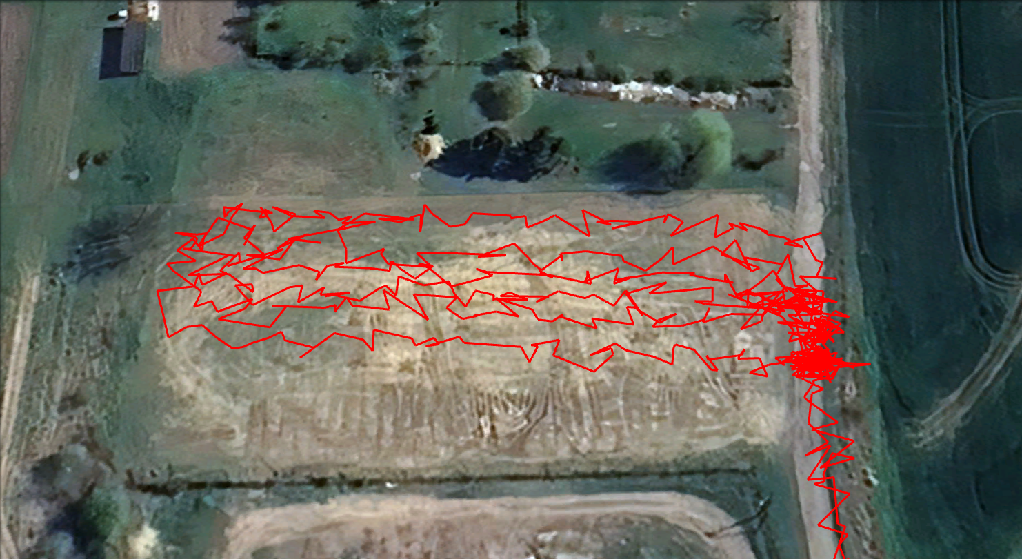
Signal interference or spoofing can silently disrupt positioning — grounding drone fleets, stopping tractors mid-operation, or forcing autonomous vehicles into fallback mode before operators even understand what went wrong.
Correction services are fragmented and hardware-bound. Expanding across regions often means vendor lock-in, new integrations, and rising operational costs.
Most systems provide coordinates — not confidence. When positioning quality drops, teams often discover it only after delays, damage, or compliance risks.
High-precision positioning without resilience is no longer sufficient for mission-critical systems. Navvego defines the next layer: resilient, measurable, infrastructure-grade PNT.
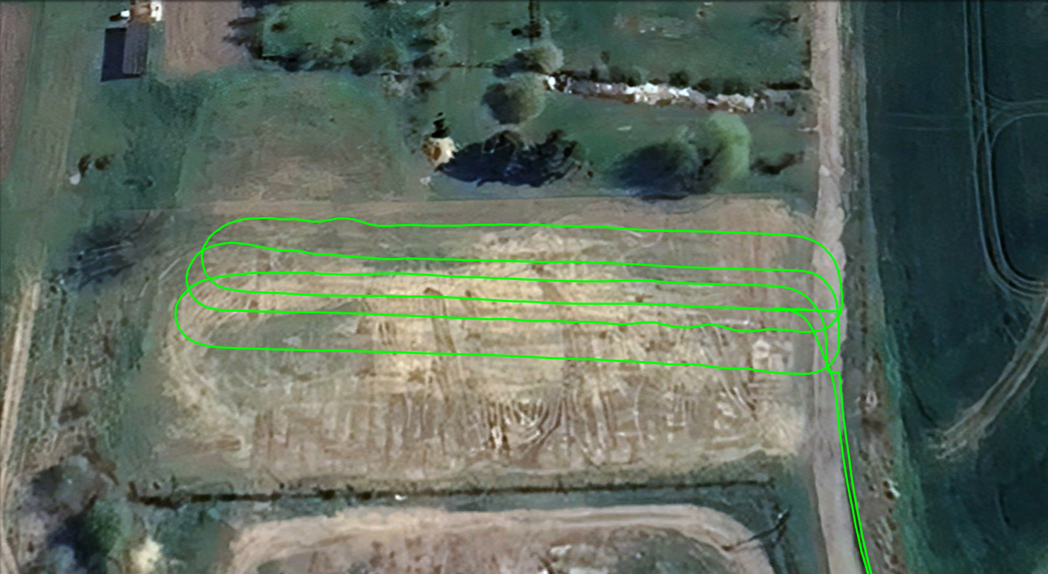
Navvego turns positioning from a fragile signal into operational infrastructure you can trust. We combine precision, integrity monitoring, and open system design — so fleets stay running, machines stay accurate, and operations continue even under real-world disruption.
Stable accuracy with fewer dropouts and faster recovery. Centimeter-level precision where it matters.
Know when positioning is degraded — before it becomes a failure.
Works across receivers and providers — no rip-and-replace.
Navvego closes the loop between satellites and your machines — delivering precise, safe, and open positioning worldwide.
Definitions:
Designed for operations where a positioning failure is not an inconvenience — but a shutdown.
Software-based positioning reliability layer
Keeps fleets accurate across regions without retooling.
Interference & anomaly detection
Detect disruption before it becomes downtime.
Sub-second anomaly awareness (depending on integration setup).
Visibility & diagnostics
Make positioning quality visible to operations teams.
Delivered as a software-based positioning reliability layer — without replacing your hardware stack.
Most positioning solutions optimize accuracy. Navvego optimizes operational resilience.
| Capability | Traditional solutions | Navvego |
|---|---|---|
| Works with existing receivers | Sometimes | Yes |
| Integrity & anomaly awareness | Limited | Built-in |
| Vendor lock-in | High | Low |
| Hybrid satellite readiness | No | Built for it |
| Real-time operational visibility | Low | Cockpit |
Drag the bar to compare
We support positioning-critical applications across industries where reliability, precision, and openness matter.
Reliable centimeter positioning during harvesting and field automation.
Maintain stable navigation during autonomous missions.
High-integrity positioning for advanced driver systems.
Operational continuity in positioning-critical zones.
Reduce downtime across distributed fleets.
Consistent precision without provider lock-in.
We execute with pilots — not promises.
From core technology to global open PNT platform — this is where we are and where we are going next.
Current focus: deploying MVP with selected partners.
We got tired of seeing positioning fail in real operations. So we built a control layer that makes high-precision positioning open, reliable, and measurable.
We've spent the last 15 years inside the world's most demanding positioning systems — aerospace, automotive, agriculture, and robotics across three continents. We know exactly why today's solutions fail users in the field, and we got tired of it.
So we started Navvego to do it right: open, widely accesible, future-proof, and agnostic.

13+ years shipping high-precision GNSS and safety-critical systems for agriculture, automotive and mobility in America, Europe and Asia.
Former System Architect & Functional Safety Manager (ISO 26262, IEC 61508, ISO 21448, ISO21434 and ASPICE).
Built high-quality GNSS products (measurement engines, positioning engines and correction services) used on three continents by American and German OEMs.
Executive MBA from Technical University of Munich.

Aerospace engineer specialised in GNSS integrity and safety-critical navigation. Former Airbus Defence & Space engineer on the EGNOS V3 programme (European SBAS) for aviation.
Designed and validated GNSS integrity monitoring and navigation algorithms used in operational aviation and advanced air mobility systems, with a strong focus on real-world performance and robustness.
Deep expertise in taking navigation algorithms from research concepts into certified, safety-critical systems.
We are supported by leading GNSS professionals, cloud architects, and the TUM Venture Lab Aerospace ecosystem in Munich.
Positioning is not a feature for us — it is our professional foundation.
In 60 days, we deploy Navvego on your existing receivers, monitor performance in real operating conditions, and provide a structured resilience report so you can evaluate operational impact before full rollout.
Limited pilot slots available for 2026 deployment.
Let's talk about your use case — agriculture, robotics, automotive, drones, logistics, or anything in between.